(NEW YORK) — A major winter storm is making the post-Christmas travel extremely dangerous in parts of the Northeast, and the storm is set to bring the most snow to New York City in years.
The storm is also impacting flights. Nearly 800 flights have been canceled so far on Friday, with New York City’s three airports and the Detroit Metro Airport hit the hardest.
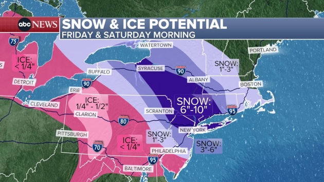
The storm first hit the Midwest. People in Wisconsin and Michigan are waking up to a layer of ice on the roads, so drivers should use extra caution.
On Friday morning, the freezing rain moves east into Pennsylvania and will cover the entire state throughout the day, making the roads extremely treacherous. An ice storm warning is in place for nearly 1 million people in parts of western Pennsylvania.
On the north side of this storm, where temperatures are cold enough to create snow instead of ice, heavy snowfall is expected in parts of New York, eastern Pennsylvania, New Jersey, Connecticut, western Massachusetts and Rhode Island.
The snow will begin in western New York on Friday morning and reach New York City by 5 p.m. Friday.
The snow will be heavy at times and will greatly reduce visibility, making travel treacherous.
The snow will continue overnight, ending in New York City around 9 a.m.
New York City is forecast to get about 7 inches of snow — the most snow in nearly four years.
A winter storm warning in place for the tristate region. Six to 9 inches of snow is possible in upstate New York, with 10 inches possible in the Hudson Valley. Five to 8 inches is forecast for northern New Jersey, while Hartford, Connecticut, could get about 4 inches.
Philadelphia can expect 1 to 3 inches of a sleet and snow mix, along with a glaze of ice, making travel challenging on Friday night. Baltimore can also expect icy roads.
Copyright © 2025, ABC Audio. All rights reserved.
Never miss out on local news. Sign up below for Tri-County Insider News: